
07 3396 9988
Newcastle Harbour
SKU:
AUS208 Category:
$0.00
Description:
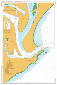
AUSTRALIA CHART 208 - Newcastle Harbour
Chart Number Aus208
Title Australia East Coast - New South Wales - Newcastle Harbour
Geog Location Australia
North Lat 32 52.60 S
South Lat 32 56.80 S
East Long 151 48.61 E
West Long 151 45.47 E
Scale 1:7500
Projection universal transverse mercator
Pub Date 24-May-1972
Edition Date 18-May-2012
Chart Number Aus208 (subchart 1)
Title Hunter River (South Arm)
Geog Location Australia
North Lat 32 52.59 S
South Lat 32 53.39 S
East Long 151 45.72 E
West Long 151 43.98 E
Scale 1:10000
Projection universal transverse mercator
Pub Date 24-May-1972
Edition Date 18-May-2012
Additional Info:
The Australian Hydrographic Service currently has over 400 paper charts. All our charts are fully corrected and update to date with the latest Notices to Mariners. The Australian Hydrographic Service was established, and assumed responsibility for hydrographic surveys in Australia, in 1920. In 1946, Cabinet decided that the Royal Australian Navy (RAN) would maintain the national responsibility for hydrographic surveying, nautical charting and the provision of hydrographic services.
Delivery Approximately 3 Days