
07 3396 9988
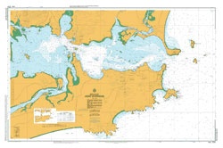
Port Stephens
SKU:
AUS810 Category:
$0.00
Description:
Port Stephens
Chart Number Aus810
Title Australia East Coast - New South Wales - Port Stephens to Crowdy Head
Geog Location Australia
North Lat 31 47.00 S
South Lat 33 13.00 S
East Long 153 05.40 E
West Long 152 06.00 E
Scale 1:150000
Projection mercator
Pub Date 14-Sep-2001
Edition Date 17-Mar-2006
:: Notices to Mariners ::
2012 1174
2011
2010 730t
2009 1351 691 355 38 36 34
2008 1170
2007 464
Additional Info:
The Australian Hydrographic Service currently has over 400 paper charts. All our charts are fully corrected and update to date with the latest Notices to Mariners. The Australian Hydrographic Service was established, and assumed responsibility for hydrographic surveys in Australia, in 1920. In 1946, Cabinet decided that the Royal Australian Navy (RAN) would maintain the national responsibility for hydrographic surveying, nautical charting and the provision of hydrographic services. RAN is responsible for meeting Australia's obligations to provide hydrographic services as required by the International Convention for the Safety of Life at Sea (SOLAS). Its traditions and methods take their origins from those of the Royal Navy and the pioneers of hydrography.
Delivery 3 Days