
07 3396 9988
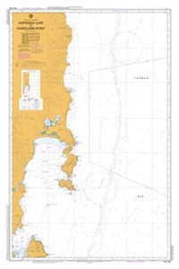
Mistaken Cape to Wardlaws Point
SKU:
AUS776 Category:
$0.00
Description:
AUS CHART 766 - Mistaken Cape to Wardlaws Point
Chart Number Aus776
Title Australia South Coast - South Australia - Williams Island to Winceby Island
Geog Location Australia
North Lat 34 22.91 S
South Lat 35 11.92 S
East Long 137 32.49 E
West Long 135 50.92 E
Scale 1:150000
Projection mercator
Pub Date 09-Mar-1977
Edition Date 01-Nov-2002
:: Notices to Mariners ::
2013 331 251 192 140
2012 448 38
2011 1253 690 356 97
2010 1117 913 796 489 427 304 42
2008 700 101
2007 213
2006 754 752 574 441 309 129
2005 1110 602 493 167
2004 749
2003 634 236 71 70
Additional Info:
The Australian Hydrographic Service currently has over 400 paper charts. All our charts are fully corrected and update to date with the latest Notices to Mariners. The Australian Hydrographic Service was established, and assumed responsibility for hydrographic surveys in Australia, in 1920. In 1946, Cabinet decided that the Royal Australian Navy (RAN) would maintain the national responsibility for hydrographic surveying, nautical charting and the provision of hydrographic services. RAN is responsible for meeting Australia's obligations to provide hydrographic services as required by the International Convention for the Safety of Life at Sea (SOLAS). Its traditions and methods take their origins from those of the Royal Navy and the pioneers of hydrography.